Lines of latitude and longitude together form a coordinate system whereby any place on Earth can be located. Lines of latitude and longitude have special characteristics that make them useful for not only pinpointing the location of anywhere on Earth but for helping us to understand features of our planet such as the reason for climate differences around the world and why the sun rises and sets at different times on different parts of the globe.
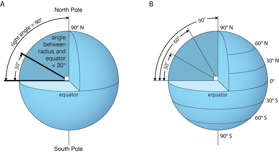
Lines of Latitude are given as a measurement of the arc that is formed from the centre of the Earth to the equator (an imaginary line drawn on the Earth, equidistant from the North and South Poles which divides the Earth in half) and another line from the centre of the Earth to a point on a line of latitude along the same line or meridian of longitude. See the illustration below.
Facts about lines of latitude:
- They cut across the Earth and are all parallel circles.
- The largest called the great circle (since it divides the Earth into halves or hemispheres) is the Equator which has a value of 0°.
- The North and South Poles both have a value of 90°.
- They are called parallels since they do not intersect.
- They intersect meridians or lines of longitude at right angles.
- They are equidistant (the same distance) from each other
- A change of one degree corresponds to a distance of 111 km along a line of longitude.
- They measure north or south of the equator.
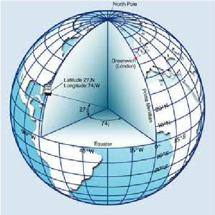
Lines of Longitude are measured by creating an arc from drawing an imaginary line from the centre of the Earth to the intersection of the equator and the prime meridian, then another line from the centre of the Earth to another point along the equator. See the illustration below.
IMPORTANT LINES OF LATITUDE AND LONGITUDE
Facts about lines of longitude:
1. Also called meridians, they run in a north to south direction
2. They are equal in length and are all great circles (which means they bisect the Earth into halves or hemispheres) when paired with the lines on the opposite side of the globe.
3. They are furthest apart at the equator (111 km apart) but they meet at the poles.
4. They intersect lines of latitude at right angles.
5. They measure east of west of the prime meridian at 0°,(an imaginary line passing through Greenwich London) up to 180° east or west of this line.
6. They lie in planes that pass through the Earth's axis (an imaginary pole running through the centre of the Earth about which it rotates).
7. The 180° line is known as the International Date Line (IDL) since crossing it means losing or gaining a day.
Did you know that unlike lines of latitude that have fixed physical characteristics, the lines of longitude are arbitrarily chosen? For example, the 0 degree line of longitude which is the starting point for measuring distances between east and west of the prime meridian passes through the Royal Observatory in Greenwich, London. However, it could have been placed anywhere!

'DISCOVERERS' OF LATITUDE AND LONGITUDE
Read this article and this article then complete the activity below.
How much do you know about latitude and longitude? Play this jeopardy game to find out!
