Types of Rainfall
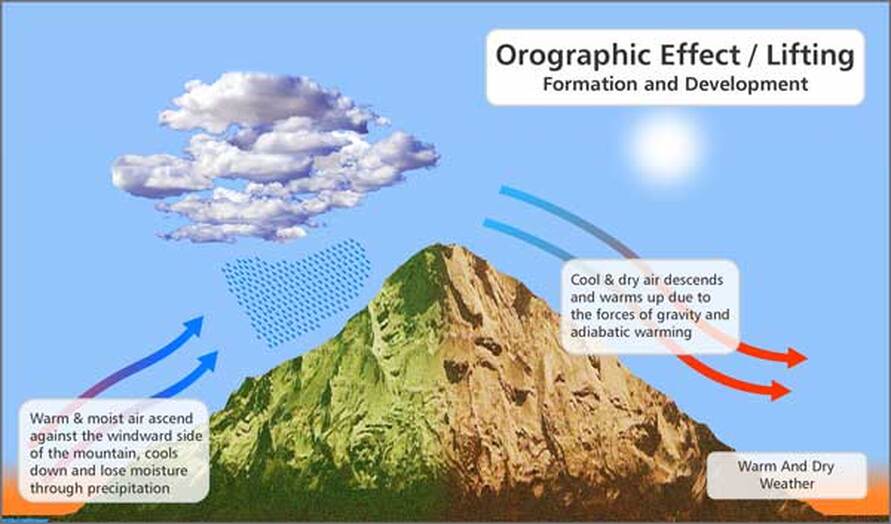
Orographic or Relief Rainfall occurs when warm moist air that has been blowing over bodies of water is forced to rise on reaching physical barriers such as highlands. The rising air cools at about 1 degree Celsius per 100 metres and condenses when relative humidity is at around 100%. The water droplets formed in water vapour clouds eventually grow heavier as more and more condensation occurs until gravity pulls them down to the Earth as rain. The side of the mountain that is continually subjected to the prevailing winds is called the windward side. The opposite or leeward side is where the dry air descends after its moisture has been released in the form of rain showers.
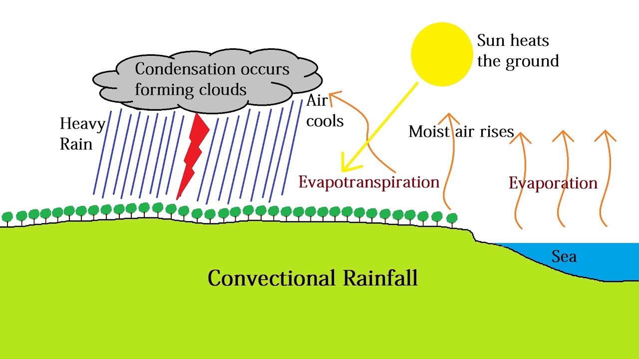
Convectional Rainfall occurs over land that is subjected to the Sun's intense heat. Terrestrial radiation coming form Earth's surface heats up the lower levels of the atmosphere. This warm air (sometimes called thermals) begins to rise through the atmosphere at speeds of up to 25 metres per second due to its low pressure until it reaches a level where it starts to cool adiabatically. On reaching saturation point water droplets form in clouds, eventually leading to rainfall. Convectional rainfall can become intense if there is steady stream of warm rising air to fed a cumulonimbus cloud. However, the heavy rainfall will eventually cool the ground, effectually shutting off the supply of warm air needed to fuel more showers. Convectional rainfall is therefore notorious for being intense but brief thundershowers that occur in the afternoon after maximum diurnal temperature has been reached.
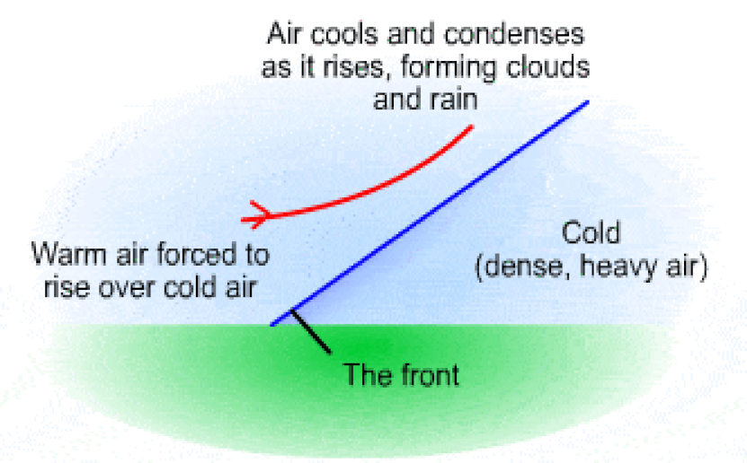
Frontal or Cyclonic Rainfall occurs at the boundaries of two air masses of varying temperatures and densities. One air mass is usually forced upwards and over the other and this instability leads to the development of showers, following the rising, cooling and condensation process. Often at a cold front the lighter warm air is pushed over the heavier and denser cold air mass. However, at times a mass of warm air moves faster than the colder air thereby vertically displacing it at the boundary. There are several permutations of cyclonic weather when warm and cold air masses interact differently. These include weather conditions associated with cold fronts, warm fronts, quasi-stationary fronts and occluded fronts.
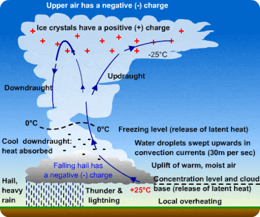
Thunderstorms develop where ideal conditions exist for the following:
Thunderstorm intensity and duration are affected by several factors including the height of the cloud - upper atmospheric temperatures below freezing cause water to cool more rapidly and heavier precipitation can produce large droplets or hail; the tilt of the cloud - so that the downdrafts do not cancel out the updrafts; the heat and moisture source as well as the degree of instability in the atmosphere which work together to fuel the system.
- - continuous updrafts of warm moist air high into the troposphere
- - rapid condensation and downdrafts of super.cooled air and water to produce heavy rainfall and gusty winds
- - the creation of an electrical field within cumulonimbus cells, where varying temperatures along with rising and falling water droplets produce negative and positive electrons that interact with each other (hence lightning and thunder)
Thunderstorm intensity and duration are affected by several factors including the height of the cloud - upper atmospheric temperatures below freezing cause water to cool more rapidly and heavier precipitation can produce large droplets or hail; the tilt of the cloud - so that the downdrafts do not cancel out the updrafts; the heat and moisture source as well as the degree of instability in the atmosphere which work together to fuel the system.
|
|
|
Theories of raindrop formation
Not all condensation leads to precipitation. Condensation produces water vapour clouds, but many times we may observe clouds in the sky that produce no rain. Some people on high elevations may have even noticed tiny rain drops that seem to evaporate before they hit the ground, the meteorological term for which is known as virga. So what then determines whether rainfall is produced of not? There are two main theories put forward to explain raindrop formation. These are known as Longmuir's Collision and Coalescence theory and the Bergeron-Findeisen's Ice Crystal Mechanism theory.
Not all condensation leads to precipitation. Condensation produces water vapour clouds, but many times we may observe clouds in the sky that produce no rain. Some people on high elevations may have even noticed tiny rain drops that seem to evaporate before they hit the ground, the meteorological term for which is known as virga. So what then determines whether rainfall is produced of not? There are two main theories put forward to explain raindrop formation. These are known as Longmuir's Collision and Coalescence theory and the Bergeron-Findeisen's Ice Crystal Mechanism theory.
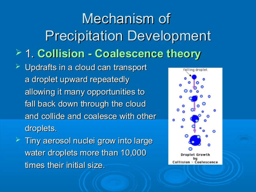
Collision-Coalescence Theory
Moist rising air cools to form water vapour clouds. When cooling reaches saturation point droplets begin to form but are too tiny and light to make it down the the Earth's surface as rain so much of it may dissipate while suspended within the cloud or evaporate as it passes through the atmosphere. However. within a cloud there convection currents which facilitate the continuous updrafts of moist air. Water droplets (from updrafts and downdrafts) collide to form larger droplets that now have enough weight to fall to the ground as rain. Even though they are still being ripped apart on their way down by further updrafts, they are just broken into smaller raindrops.
This theory has widely been used to explain the convectional rainfall of tropical regions.
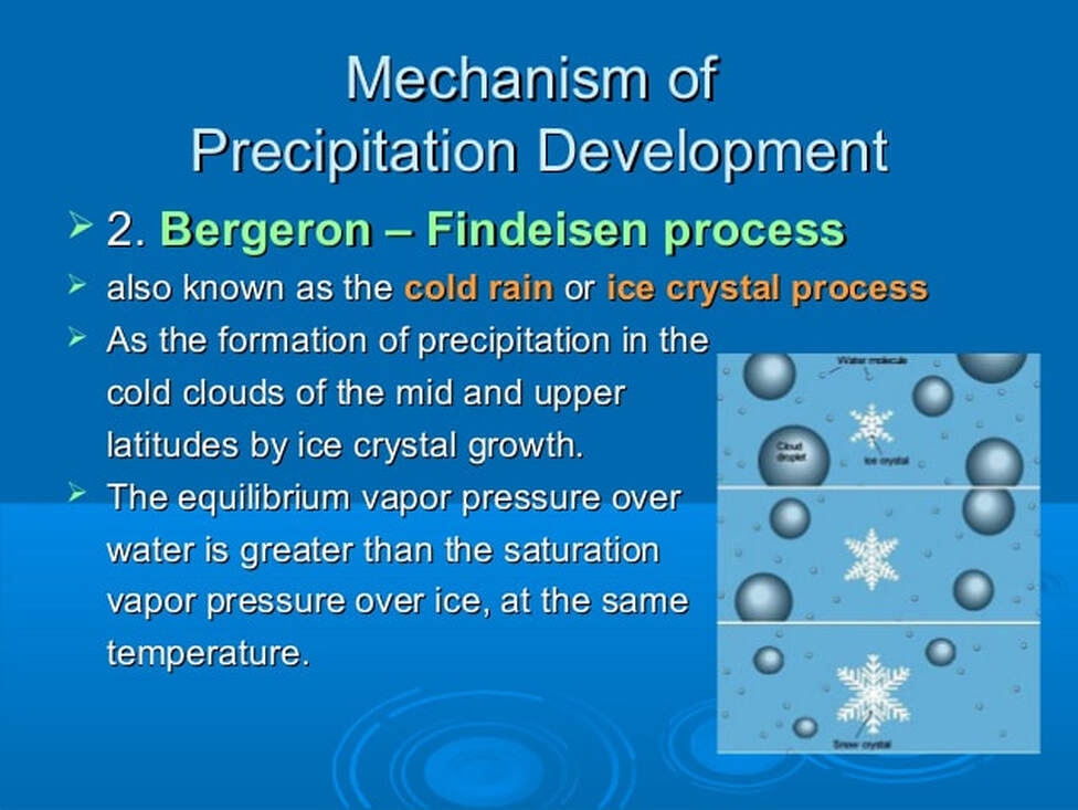
Ice Crystal Mechanism Theory
Also known as WBS, named after Wegener, Bergeron and Findeisen (Alfred Wegener has often been credited to have discovered this first!), this theory applies more to middle and high latitudes where towering cold cumulonimbus clouds create an environment for ice crystal formation in sub-zero conditions high in the atmosphere.
Tiny droplets of water also exist at this level and it is called super-cooled water since it remains in a liquid state though its temperature is below the normal freezing point of zero degrees Celsius. Saturation required for the formation of raindrops requires more water vapour molecules around water surfaces than around ice surfaces, therefore a water vapour pressure gradient develops between the water droplets and ice crystals within the cold cloud. Similar to wind development, where air molecules blow from high to low pressure areas, so too does the moisture in the cloud move from the high pressure around the water droplets to the lower pressure around the ice, causing the ice crystals to grow at the expense of the water droplets. When these snowflakes are heavy enough they begin to fall through the sky. Whether or not they hit the ground as rain or snow depends on the temperature conditions through which the snowflakes fall.
How much can you remember? Try this Crossword puzzle to find out!
