Maps are essential tools for geographers. the main elements of maps include the title, scale, compass direction and legend. Maps can be used to spatially represent any natural or human feature on earth. The key to understanding maps and utilizing them effectively lies in mastering a few skills that, in combination, constitute the 'language' of map reading.
MAP TYPES
There are several types of maps:
There are several types of maps:
- Geological: Shows the types of rocks and geological structures such as folds in an area. These are useful for land developers and geoscientists.
- Geographical: General maps that highlight main human and physical features such as major cities, mountains and water bodies.
- Physical : Focuses on natural features of the earth such as mountains, and water bodies.
- Climate : Shows the average weather conditions of a region which give rise to a specific climate over a period of time.
- Economic: Shows the different types of industries that operate within a country.
- Political: Shows national borders between countries or administrative districts within countries.
- Topographic: Shows the shape and character of the earth's surface. They are sometimes called contour maps since most of them are recognized for their distinct contour lines. However, in addition to land and water features they also provide information about major human features such as settlements, communication/transportation networks and other land uses.
- Road: Road maps have become increasingly ubiquitous with the rise of tourism and international travel. These type of maps focus on major road networks and are useful for both local and foreign motorists and commuters moving around a country on their own.
- Thematic or specialty maps refer to maps that show the spatial distribution of any theme under the sun - from disease outbreaks to historical journeys, to levels of poverty and so on. It starts off with some of the basic elements of a general map then it is overlaid with specific information on which the cartographer wants the reader to focus. Another sub grouping of map types under thematic maps concerns itself with how information is presented. For example dot maps, choropleth maps and isoline maps.
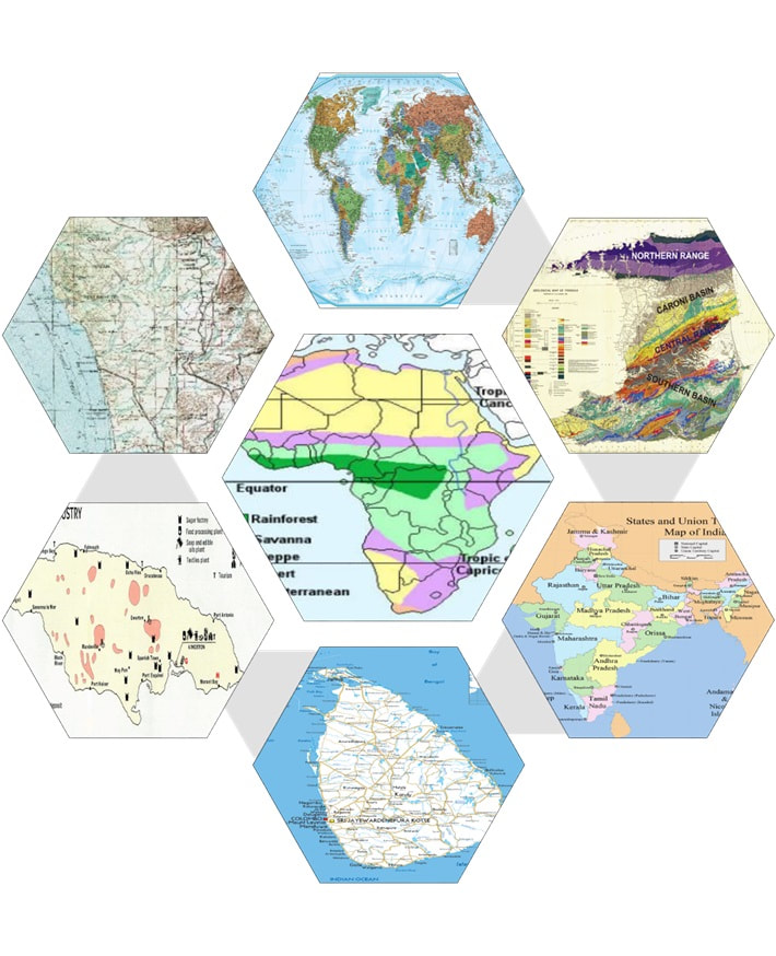
TASK 1 : Can you tell which type of map each hexagon depicts?
Answers
TASK 1
Top : geographical Top right: geological Bottom right: political Bottom centre: road map Bottom left: economic Top left: Topographic Centre: climate
TASK 1
Top : geographical Top right: geological Bottom right: political Bottom centre: road map Bottom left: economic Top left: Topographic Centre: climate
Click on the arrow to view the Prezi presentation below
MAP SCALE
Scale: this expresses the relationship between distance on a map and real distance on the ground. It can be written in four ways:
Scale: this expresses the relationship between distance on a map and real distance on the ground. It can be written in four ways:
- A statement : 1 cm represents 1 km
- A fraction: 1/100 000 (numerator and denominator must be in the same units, e.g., cm or mm)
- A ratio: 1 : 100 000 (units on both sides must be the same, e.g., cm or mm)
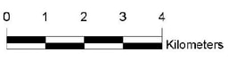
- A linear scale: On the scales shown below, vertical separators or colour changes represent a change in distance of one km. The scale on the left has also sectioned off portions of 1 km for measuring distances under 1 km more accurately.

|
|
Task 2 See if you can answer the following questions on your own:
- If the space between two places on a map is 4 cm and the map scale is 1 :100 000, then what is the actual distance on the ground?
- If the distance between two places on a map is twice the length of the line of the linear scale shown above on the right, then what is the actual distance on the ground?
- The actual distance between two places is 10 km and the distance on the map is 5 cm. What is the sale of the map? (Write as a ratio or fraction)
- It was found that two places were 350 000 cm apart in real distance. On the map it is 7 cm apart. Write the scale for this map using a statement.
On a question paper, you can also be asked to calculate straight-line distance or distance along a road or coast. Straight-line distances (also called "as the crow flies" and "bee line") are determined by using a ruler or straight edge and aligning the reading to a linear scale or working out the conversion of cm to metres, km or miles. Distances that are curved would require the use of a string or a thin piece of paper that can be bent easily.
Large and Small Scale Maps:
Most countries displayed in atlases are small scale maps. They a small in size and they show the entire coastline or land boundaries but with few details. Maps that show a portion of a country are called large scale maps. These allow for more detail and uses much more space on a sheet of paper.
Task 3 Would you use a large scale map or a small scale map for the following purposes?
Click on the arrow to view the You Tube video below!
Large and Small Scale Maps:
Most countries displayed in atlases are small scale maps. They a small in size and they show the entire coastline or land boundaries but with few details. Maps that show a portion of a country are called large scale maps. These allow for more detail and uses much more space on a sheet of paper.
Task 3 Would you use a large scale map or a small scale map for the following purposes?
- To find the closest bus station to a school.
- To identify the countries that border Venezuela.
- To identify the dominant land use in an area.
- To determine the extent of the Himalayas mountain range.
- To determine the length of a major road in a Caribbean island.
Click on the arrow to view the You Tube video below!
Answers
Task 2
1. 4 km 2. 8 km 3. 1:200 000 4. 1/50 000 or 1:50 000
Task 3
1. large scale 2. small scale 3. large scale 4. small scale 5. large scale
Task 2
1. 4 km 2. 8 km 3. 1:200 000 4. 1/50 000 or 1:50 000
Task 3
1. large scale 2. small scale 3. large scale 4. small scale 5. large scale
HOMEWORK: 1. Look at your atlases or view different types of maps online and try to identify which type of maps they are.
2. Practice using the scales of large and small scale maps to find distances between places.
2. Practice using the scales of large and small scale maps to find distances between places.
