Tropical waves (also called Tropical Easterly Waves or African Easterly Waves): usually affect the Caribbean region from about the month of June to November. They are troughs of low pressure with a north to south orientation that move off the African coast eastwards to the Caribbean. They appear as an inverted "V" on weather maps as the atmospheric pressure drops along squall line that makes up the trough - the isobars appear to form an indentation upwards, along this axis of thunder showers. This form is maintained until the showers dissipate or, further development causes clouds and winds to begin rotating around the low pressure area.
Characteristics:
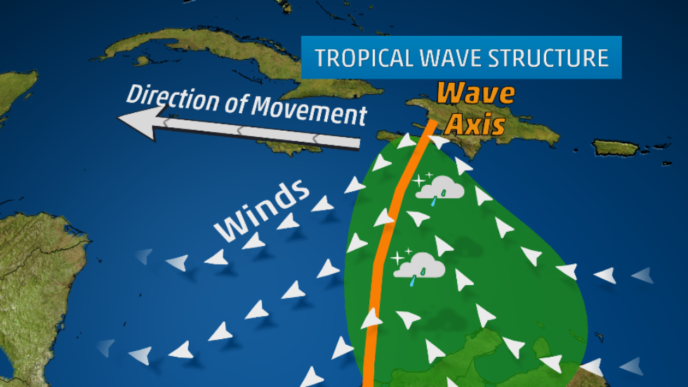
Characteristics:
- West of the wave winds are diverging outwards creating fair weather
- Along the squall line there are showers .
- To the east, the weather deteriorates there are strong updraughts into the area of low pressure creating heavy thundershowers with winds blowing southeast.
Atlantic Hurricanes: these develop from tropical waves to topical depressions with maximum sustained winds of 62 km/h, to tropical storms with winds between 63 and 118 km/h then finally into hurricanes with winds of 119 km/h and over. They affect the Caribbean region from June to November each year.
Characteristics:
Characteristics:
- These are powerful cyclones that develop over warm deep tropical ocean waters of at least 27 degrees Celsius.
- The continual energy feed of warm waters, an absence of shear winds and the enhanced Coriolis effects allow more and more thunderstorms to develop due to deep convection currents ; clouds and winds begin to spin as they rotate around a central area of low pressure.
- The lower the pressure the more intense the storm becomes. Continual updraughts of warm light air in a low pressure area condenses to create cumulonimbus clouds and heavy thunderstorms. Remember also that winds develop as air attempts to move from high to low pressure. Therefore the sudden and extreme drops in pressure means faster wind speeds as air is sucked into the storm.
- The hurricane is so named not only because of the wind speeds but the development of an "eye", the area of the most severe storms. Though the eye is calm, it is surrounded by towering cumulonimbus clouds and the strongest winds of the system.
- Hurricanes move form east to west then to the north east as it approaches the North American continent. Sometimes they move straight towards Central America and affects countries there.
- Besides the infamous "eye" there are other notable features of a hurricane. There is a cirrus canopy upwards of 15 km of light winds that spiral up and outwards.
- In the Northern Hemisphere, winds in a hurricane rotate counter-clockwise.
- Around the eye there are strong convective updraughts but within the eye itself sinking air leads to calm weather.
- When the storm approaches there is a calm as air is sucked into the storm.
- Feeder bands eventually begin to affect the area with light showers and some strong gusts.
- To the west of the eye winds blow from the north.
- When the eye approaches, there is a sudden drop in winds and at times one can actually see clear blue skies.
- Storm surge: on the coast, the low pressure of the eye lifts the surface of the water into a mound that surges inland, pushed on by the eye-wall winds as a wall of water, causing devastating coastal flooding.
- After the eye passes, winds pick up again, this time blowing from the south.
- As the system passes heavy rain may continue for several days after.
- Hurricanes do not usually move towards the equator, as the Coriolis effect there isn't strong enough to cause winds to spin.
- Hurricanes have predictable paths but as complex systems, they can sometimes behave out of character. For example, Hurricane Lenny in 1999 that moved from west to east through the Caribbean, damaging the leeward sides of coasts.
- When hurricanes move over land, or there is not enough warm water, or when there are shear winds present, or when a hurricane moves out of tropical regions they lose their hurricane characteristics and often die.
- Other times they may continue to move as a mid-latitude storm (minus the eye) and affect Canada or the United Kingdom.
- Each year the World Meteorological Organisation puts out a list of names that are used to name hurricanes for ease of reference. Each list is used on a six-year rotation. When an especially catastrophic storm strikes, the name is sometimes retired.
- The Saffir-Simpson Scale is used to rank hurricanes according to their sustained wind speeds. A category 1 is the weakest while a category 5 is the strongest.
- Hurricanes are tracked in several ways by different instruments which measure cloud movement, rain, wind speeds and direction, path movement and atmospheric pressure as well as other characteristics. They employ methods such as radar, satellite imagery and airplanes that actually fly into the storm to conduct measurements. These data make it possible to track a hurricane's movement and determine how to best avert danger.
Click here to watch this You tube video that explains how hurricanes develop.
